
Insights ·August 1, 2026
Drone Photography for Construction Sites: What Developers Need to Know
Professional drone and aerial photography for construction documentation. Licensed Part 107 pilot serving Charleston developers and GCs.
I'm a licensed pilot. Part 107 certified, with hundreds of flight hours across the Southeast. And I bring that pilot's mindset to every construction site I photograph.
Why does that matter? Because drone photography on active construction sites isn't a casual hobby—it's regulated, safety-critical work that requires real expertise, insurance, and a commitment to professionalism.
If you're a developer, general contractor, or project manager considering aerial documentation for your construction project, understanding what goes into professional drone work will help you evaluate vendors, manage expectations, and get real value from your investment.
The Regulatory Reality: Part 107
First, the legal baseline: anyone flying a commercial drone over a construction site needs to be Part 107 certified by the FAA. That means passing an exam, understanding airspace regulations, knowing how to operate in specific weather and safety conditions, and maintaining currency.
Some people think this is overkill. It's not. Part 107 exists because drones operated negligently can cause injury or property damage. The regulations ensure that pilots understand how to operate safely around buildings, power lines, personnel, and equipment.
When you hire a drone photographer for construction documentation, verify that they hold an active Part 107 certificate. Ask to see it. A legitimate operator will have it readily available and understand why it matters to you.
What Aerial Construction Documentation Actually Looks Like
Construction documentation using drones is more nuanced than "take a photo from the air." Here's what I typically deliver:
Orthomosaic views: These are straight-down perspectives that show the roof, the building footprint, site layout, and progress in a clear, measurable way. Useful for tracking how much of the roof is covered, where work is concentrated, and the overall pace of construction. These images are often used in comparison sequences (Week 4 vs. Week 8 vs. Week 12) to show progress visually.
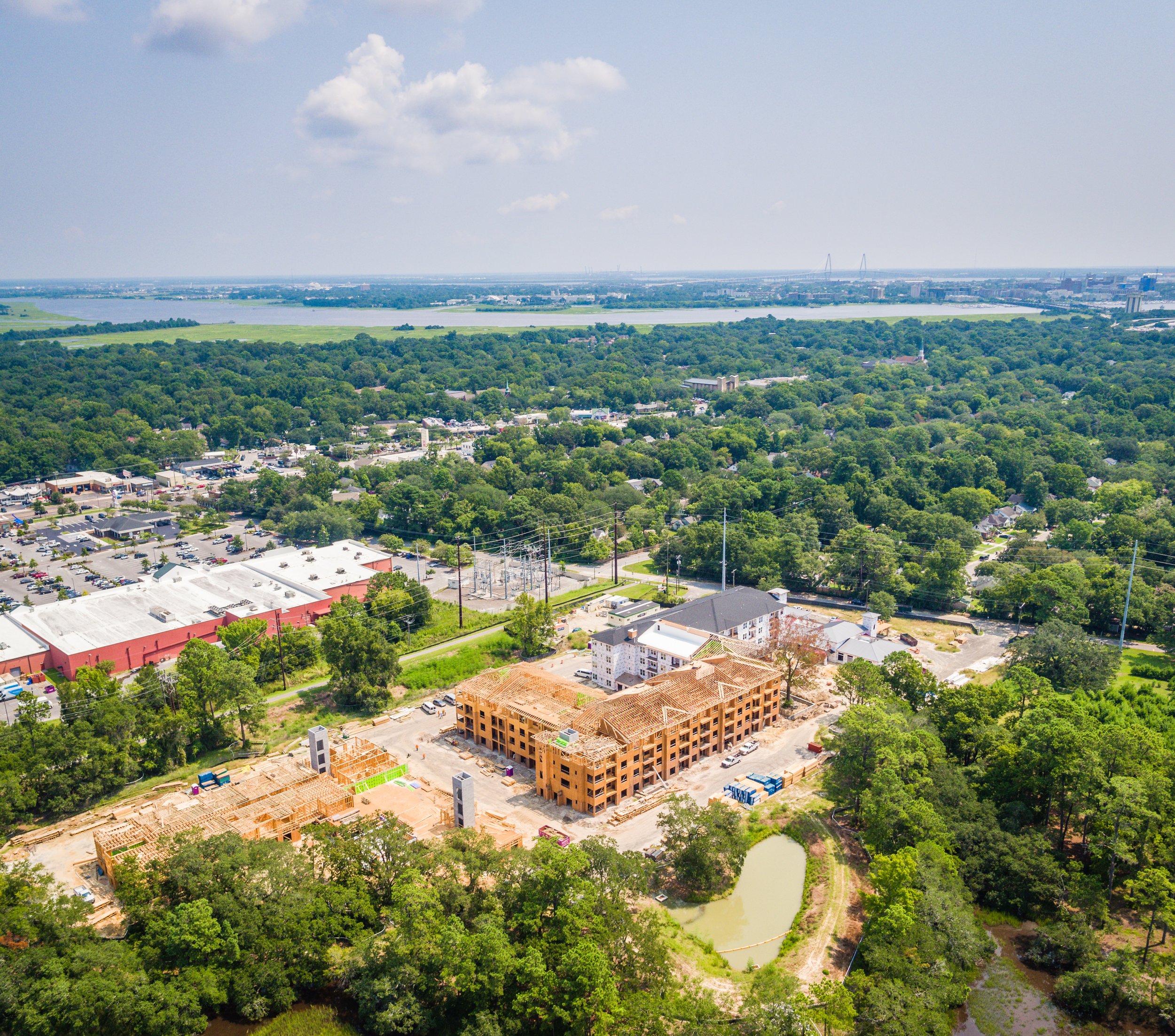
Oblique angles: 45-degree perspective shots that show both the vertical progress of the building and its relationship to the surrounding site. These are the images that give investors and stakeholders a visceral sense of the building's scale, architectural character, and context.
Site overview: Wide shots that show the entire project footprint, adjacent properties, traffic patterns, and neighborhood integration. Especially valuable for multifamily, mixed-use, and commercial developments where context matters for leasing and marketing.
Detail shots: Closer frames of specific features—façade progress, roofing systems, amenity spaces, or architectural details—that need documentation without the full-site perspective.
Progress comparison sequences: Before, mid-project, and completed comparisons that visually demonstrate the transformation. These are powerful for investor presentations, marketing materials, and project documentation.
Why Frequency Matters
How often should you photograph a construction site? That depends on the project timeline and your documentation goals.
Monthly documentation is standard for most projects. Spaced at regular intervals throughout the construction duration, monthly shots create a clear visual timeline and help identify pacing issues or delays. Monthly cadence also works well for investor updates—a single slide showing six months of progress is a powerful communication tool.
Milestone-based documentation is appropriate when you want to capture specific completion moments: foundation complete, structural frame complete, roof done, interior finishing underway, final completion. This approach creates a tighter narrative and is often used in marketing and project marketing.
Weekly documentation is rarely necessary unless you're managing a critically time-sensitive project or need granular daily tracking for contractual or dispute purposes.
For most projects, monthly is the sweet spot between comprehensive documentation and cost-efficiency.
Insurance and Safety on Active Construction Sites
Here's where my pilot's mindset becomes essential. A construction site is a complex environment: equipment moving, personnel working at height, power lines, narrow clearances, weather changes. Flying a drone safely requires that I understand the site layout, coordinate with the general contractor and site supervisor, know where personnel will be, and have contingency plans if conditions change.
Before every shoot, I:
• Coordinate with the site supervisor about timing, location, and any active work that might conflict with flight operations
• Scout the site on foot to identify obstacles, hazards, and optimal flight paths
• Check weather conditions and airspace (other aircraft, airspace restrictions)
• Confirm insurance coverage for the specific project
• Brief anyone on-site about where I'll be operating and what to expect
• Execute flights during times when the site is as controlled as possible
This isn't dramatic—it's just professional. A casual drone operator might show up, take some quick footage, and leave. A certified professional takes time to do the work safely and thoroughly.
Drone Photography Across Project Stages
Construction projects move through distinct phases, and each phase benefits from different aerial documentation:
Pre-construction: Site overview, existing conditions, surrounding context, traffic patterns. Valuable as a baseline for comparison and for marketing materials showing the "before."
Foundation and sitework: Orthomosaic shots showing excavation depth, foundation layout, utility lines. Useful for tracking pace and identifying any issues with the foundation scope.
Structural frame: Dramatic progress happens here. Oblique shots showing the building taking shape, the relationship between floors, and the final building profile are powerful for investor updates and marketing.
Exterior envelope and mechanical systems: The building is mostly defined now. Aerial shots show roofing progress, façade systems going up, and the overall aesthetic taking shape.
Interior finishing: From the air, progress slows visually. But roof-down orthomosaics can show which interior zones are progressing and highlight any remaining exterior work.
Final completion and occupancy: Aerial shots of the finished project are essential marketing assets. A professional aerial photograph of a completed development is often the hero image for investor decks, marketing brochures, and the company's own portfolio.
The Developer and GC Perspective
I work with developers, general contractors, and property managers across the Southeast. Here's what they consistently tell me:
Aerial documentation helps me communicate progress to investors. A static report with numbers and descriptions is one thing. A single aerial photograph showing a completed façade is another. Investors understand what they're looking at, and that clarity builds confidence.
We use these images for marketing before the project is done. For multifamily, commercial, and mixed-use projects, aerial photographs of progress can be used in pre-leasing materials, investor presentations, and project marketing. A six-month progress reel is a powerful leasing tool.
Dispute resolution. If there's ever a contractual dispute about pace, quality, or scope, aerial documentation provides objective visual evidence. I've had GCs tell me that monthly drone photography prevented conflicts by creating a clear record of what was completed when.
Personnel and safety accountability. Aerial documentation creates an incentive for the site to stay organized, clean, and safe. It's harder to ignore safety issues or poor housekeeping when the project is being photographed regularly from above.
The Seasonal Factor
Spring through early fall is peak construction season in the Southeast. Winter weather is more unpredictable. If you're planning a construction documentation program, early spring is ideal—the weather is increasingly stable, the days are long enough for consistent lighting, and you can photograph from project start through completion without seasonal delays.
Bringing It Together
Construction documentation with professional aerial photography is increasingly standard practice. Developers expect it, GCs benefit from it, and stakeholders rely on it. The question isn't whether to do it, but whether to do it professionally or through a casual operator.
As a licensed Part 107 pilot with years of construction site experience, I approach every project with the same rigor I bring to flying: safety first, professionalism throughout, and deliverables that genuinely serve your project needs.
Let's Document Your Project
If you're managing a construction project in Charleston or across the Southeast and you're ready to invest in professional aerial documentation, I'd welcome the conversation. I understand what developers, GCs, and project managers actually need from construction photography, and I know how to deliver it safely and professionally.
Give me a call at (843) 732-6111 or visit elliscreekphotography.com/contact to discuss your project. Let's create the documentation that tracks progress, supports decision-making, and represents your work at its best.
Continue Reading